Maps & Navigation
What Mapping Products Are Missing: A Case for Exploratory Search
Designing for geographic discovery before users know their destination
Introduction
Exploring places before the query is clear
Most consumer mapping products are designed to get users from point A to B—and they are very good at it. But try choosing where to stay in an unfamiliar location using only Google Maps, and the limits of directed search become glaringly obvious.
I partnered with a client with decades of experience in the consumer mapping industry to explore a less-explored category of mapping product. My role was to turn an expansive charter into a focused interaction model and working prototype for a wide range of exploratory search use cases.
The problem
Search works well when people know what they want
Traditional maps are optimized for directed questions. Many place-based decisions begin earlier, when people are still comparing areas, learning what matters, and deciding what to search for.
Directed questions maps already answer well
- Where is the nearest coffee shop?
- How do I get to this address?
- Which restaurant is open now?
Exploratory questions the product seeks to support
- What is this neighborhood like?
- Where are certain types of businesses concentrated?
- How does one part of a city compare with another?
- What changes as I widen or narrow the area I am considering?
Interaction model
The viewport is the query
The leading consumer maps product, Google Maps, does not support continuous queries because each query costs them money. We view this as a missed opportunity to align with the user's mental model, that the map is the query, and moving the map area signals the user's intent to change their query. We intentionally designed this product to respond to that request from the user. It is all made possible thanks to modern computational advancements using pre-computed data.
Rather than requiring users to search before the map becomes useful, we treated the visible geography as the query.
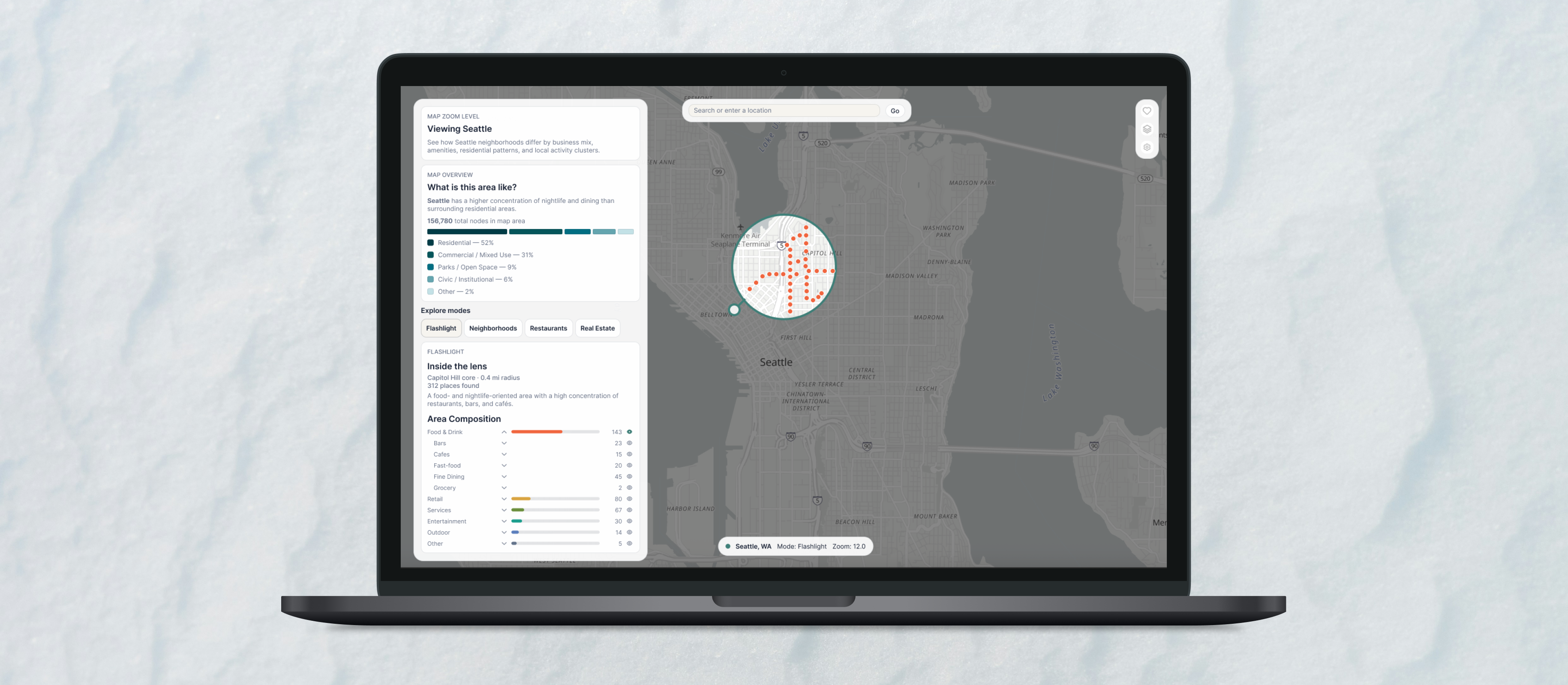
As users pan and zoom, the product nearly instantly reevaluates the area in view. The map visualizes the results while the supporting panel interprets them, keeping both surfaces synchronized without requiring repeated search submissions.
The viewport supports broad exploration, while the flashlight creates a smaller, user-defined query without removing the surrounding geographic context.
-
User pans or zooms the map
-
Viewport defines the geographic query
-
Data is aggregated for the current scale
-
Map and context panel update together
Viewport-driven context
Bridging the data with the user's mental model
The useful answer changes with geographic scale. A continent view should reveal natural systems and broad regional patterns; a neighborhood view should surface local concentrations, streets, and individual places.
I defined a scale-dependent content model in which the map representation and supporting panel move together from aggregated patterns toward specific results.
The viewport shapes the experience
Continent → Country → Region → Metro → Neighborhood → Place
The content model extends from continent to individual place. The three screens shown here focus on the broadest scales; metro and neighborhood behavior appears later in Restaurant Explorer.
Continent
Broad natural systems, major geographic patterns, and representative regions
Country
Regional structure, population patterns, climate, and major destinations
Region
Landscape character, cities, routes, recreation, and seasonal context
Feature in development
Applying the model to restaurant discovery
Where are the strongest concentrations of highly rated Chinese restaurants within the area I am willing to explore?
Restaurant Explorer applies the same map-first model to a more specific decision. Instead of a general area summary, the panel prioritizes cuisine mix, restaurant count, ratings, price, and willingness to travel.
At the metro scale, density reveals where options concentrate. As the user moves closer, the experience transitions through clusters to individual restaurants and detailed attributes.
The design must distinguish abundance from quality: an area with more restaurants may offer greater choice without necessarily being the best fit.
Metro level
Neighborhood level
Contribution
My role
I led the experience from early product framing through interaction design and prototyping.
Product framing
- Translated an expansive exploratory-mapping charter into a focused product structure and set of design principles
- Defined the viewport-driven model, distinct exploration modes, and an initial Neighborhood Explorer experience
Interaction and information design
- Designed synchronized map-and-panel behavior and a scale-dependent information model
- Created neighborhood, comparison, restaurant, and geographic-summary experiences
Prototyping and technical collaboration
- Prototyped behavior in Figma and Cursor while working alongside development rather than through a fixed handoff
- Partnered with engineering to evaluate MapLibre behavior, clustering, query cadence, data availability, and performance
A key part of this work has been defining the product behavior that connects geographic movement, data queries, visualization, and user intent.
Systems
Designing a system that aligns with user intent
Rather than designing each mode as a standalone feature, I defined a shared framework that translates geographic input into a query, an appropriate map representation, and a contextual interpretation.
Geographic input
The current experience uses the viewport and flashlight. The same model can later support boundaries, radii, routes, and travel-time areas.
Query and aggregation
Filters, counts, rankings, spatial relationships, and scale-dependent aggregation determine which data is returned.
Map representation
Heatmaps, clusters, points, polygons, and routes reveal different patterns depending on the question and geographic scale.
Contextual interpretation
The panel translates visible data into summaries, category mix, comparisons, representative places, and AI-assisted overviews grounded in source data.
What comes next
Expanding from place discovery to spatial decision-making
The current prototype establishes the foundational interaction model: geography acts as an input, and the product responds with context relevant to the visible area.
The next phase expands that framework into more specialized exploration modes and more sophisticated spatial questions.
Product roadmap
Near-term validation
- Testing whether users understand that movement through the map changes the query
- Comparing continuous updates with an optional “search this area” control
- Refining when the experience transitions between summaries, heatmaps, clusters, and individual places
Deepen Restaurant Explorer
Expand cuisine, rating, price, and travel-time exploration while connecting area-level density with individual restaurant details.
Introduce Real Estate Explorer
Help users evaluate properties through the surrounding lived experience, including access, services, recreation, commute patterns, and neighborhood character.
Add travel-time and multi-layer queries
Use isochrones and spatial joins to reveal places that satisfy overlapping constraints such as access, weather, cost, landscape, services, and recreation.
Expand visualization and comparison
Develop heatmaps, normalized density, clusters, comparative shading, and side-by-side area views so the representation matches the scale and decision.
Bring the experience to mobile
Adapt map movement, focused-area controls, filters, and supporting summaries for smaller screens and touch-first exploration without reducing geographic context.
